Saturday, 21 May 2011

The Art of Maps: A New Map Of The Terraqueous Globe According To The Ancient Discoveries And Most General Divisions Of It Into Continents And Oceans


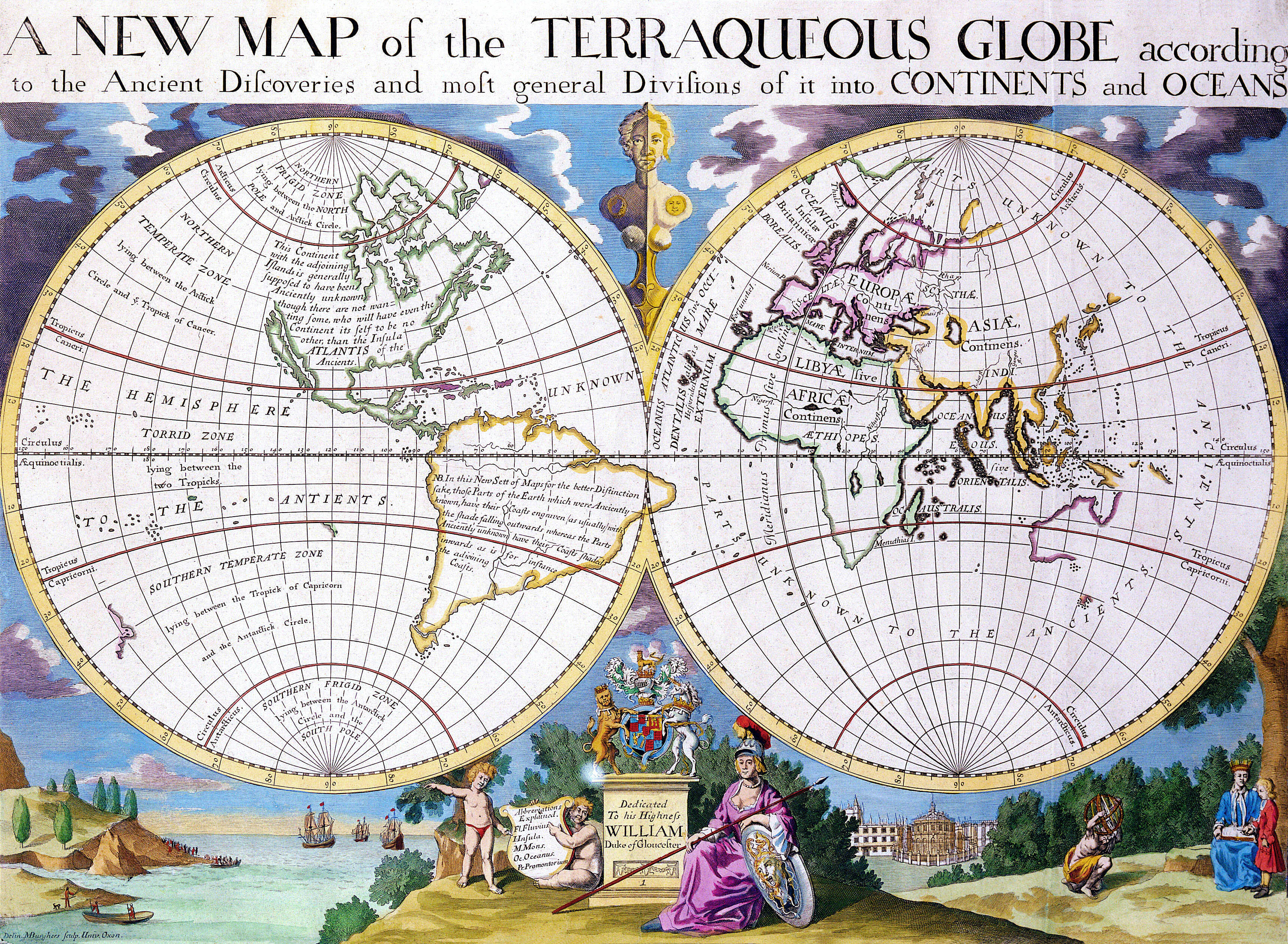
A New Map Of The Terraqueous Globe According To The Ancient Discoveries And Most General Divisions Of It Into Continents And Oceans
Edward Wells (after)
Michael Burghers (c. 1653-1727) (engraver)
Oxford: c. 1700-1738
Engraving on laid paper with Strasburg Bend & Lily watermark [Churchill 434]
17.25 x 21.25 inches overall
14.5 x 20.5 inches image


Instructional map which depicts the world in classical times, a companion piece to a map of the modern world, both of which were published by Edward Wells, teacher of mathematics and geography at Christchurch College of Oxford University. Wells labels North America as Atlantis and offers this speculation that the New World is in fact the legendary "lost continent": "This Continent with the adjoining islands is generally supposed to have been Anciently unknown though there are not wanting some, who will have even the Continent itself to be no other than the Insula Atlantis of the Ancients." California is shown as an island. Below the hemispheres is a vignette dedicated to His Highness William, Duke of Gloucester, who appears with his tutor under the tree on the right. The 13-year-old William, heir to the throne, began studies at Christchurch in 1700 at the age of 11, and died a few months after the map was issued. On either side of this are small landscapes, one of ships arriving in the New World and one of the Radcliffe Camera in Oxford.

Michael Burghers was an engraver and draftsman from Holland, who came to England and settled in Oxford in 1673. There he worked under David Loggan and succeeded him as Engraver to the University. Burghers engraved the first Oxford Almanack in 1676, and continued to engrave most of them for the next 43 years. He also illustrated books and produced architectural, botanical and portrait engravings.

Sunday, 17 April 2011

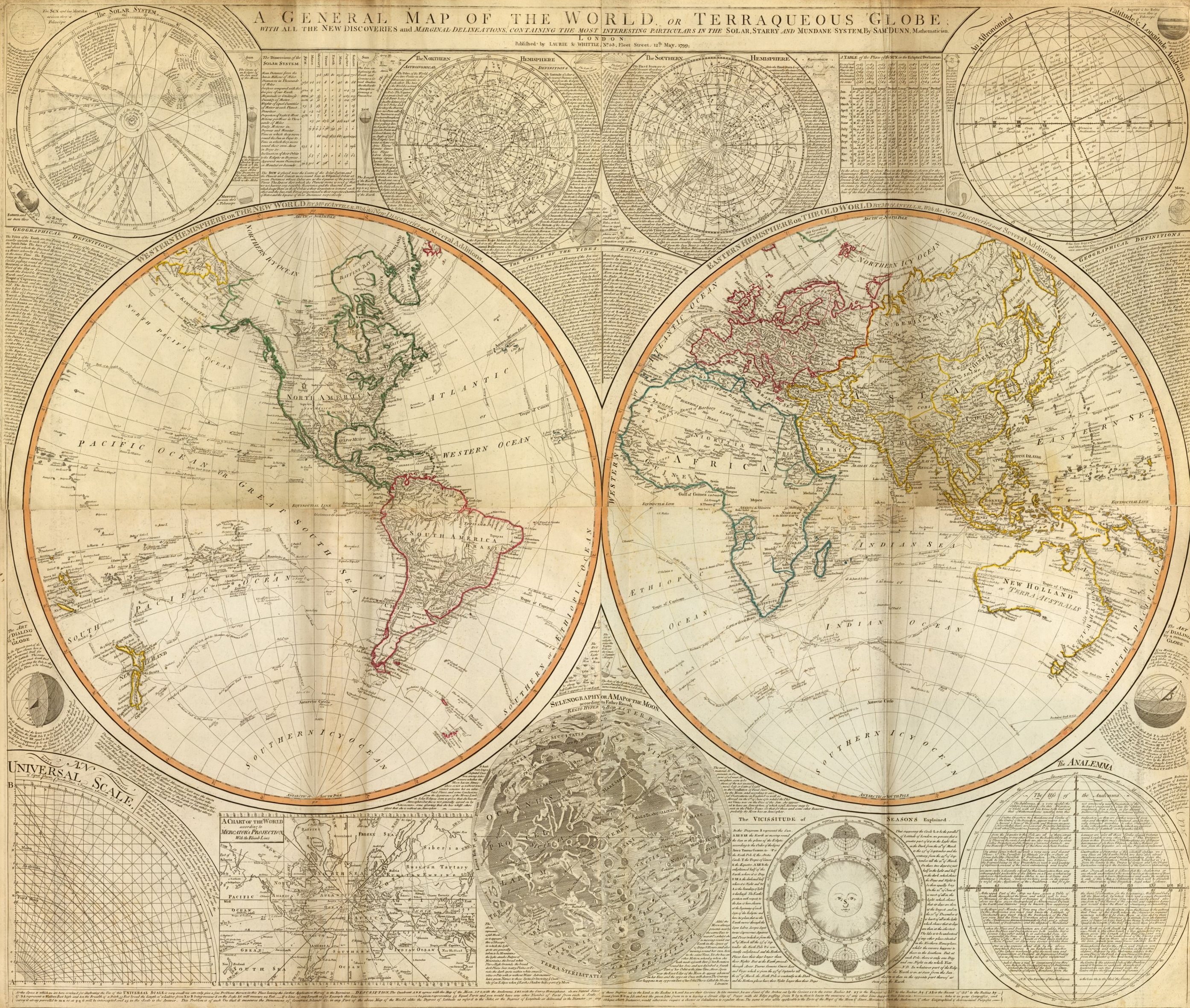
The Art of Maps: Jean Baptiste Bourguignon- A general map of the World or terraqueous globe with...


Author: Anville, Jean Baptiste Bourguignon d, 1697-1782; Dunn, Samuel; Riccioli, Giovanni Battista; Robert Laurie &
James Whittle
Date: 1799
Short Title: Composite: World.
Publisher: Laurie & Whittle London
Type: Composite Map
Obj Height cm: 105
Obj Width cm: 124
Scale 1: 43,000,000
Note:
Digital composite of north and south halves of hand colored engraved map. Relief shown pictorially. Contents: Western Hemisphere or the New World by Mr. d'Anville, with new discoveries and several additions -- Eastern Hemisphere or the Old World by Mr. d'Anville, with the new discoveries and several additions. Ancillary maps or charts: The Solar System -- The Northern Hemisphere -- The Southern Hemisphere -- An astronomical latitude & longitude analemma -- An universal scale -- A chart of the World according to Mercator's projection, with the rhumb lines -- Selenography or A map of the Moon according to Father Riccioli -- The vicissitude of seasons explained -- The analemma. Printed on 4 sheets; joined as 2.
World Area: World
Subject: Celestial
Full Title:
(Composite of) A general map of the World or terraqueous globe with all the new discoveries and marginal delineations, containing the most interesting particulars of the solar, starry and mundane system, by Saml. Dunn, mathematician. London, Published by Laurie & Whittle, No. 53, Fleet Street, 12th May, 1799.
Author: Anville, Jean Baptiste Bourguignon d, 1697-1782; Dunn, Samuel; Riccioli, Giovanni Battista; Robert Laurie &James WhittleDate: 1799Short Title: Composite: World.Publisher: Laurie & Whittle LondonType: Composite MapObj Height cm: 105Obj Width cm: 124Scale 1: 43,000,000
Note:Digital composite of north and south halves of hand colored engraved map. Relief shown pictorially. Contents: Western Hemisphere or the New World by Mr. d'Anville, with new discoveries and several additions -- Eastern Hemisphere or the Old World by Mr. d'Anville, with the new discoveries and several additions. Ancillary maps or charts: The Solar System -- The Northern Hemisphere -- The Southern Hemisphere -- An astronomical latitude & longitude analemma -- An universal scale -- A chart of the World according to Mercator's projection, with the rhumb lines -- Selenography or A map of the Moon according to Father Riccioli -- The vicissitude of seasons explained -- The analemma. Printed on 4 sheets; joined as 2.


The Art Of Maps:

Saturday, 26 March 2011

The Art of maps: John Speed: Asia with the Islands adioyning described, the atire of the people, & Townes of importance, all of them newly augmented . . . 1626

Old Maps John Speed Asia with the Islands adioyning described 1626
Asia with the Islands adioyning described, the atire of the people, & Townes of importance, all of them newly augmented . . . 1626
Map Maker: John Speed Place

Date: London / 1676

Coloring: Hand Colored             Size: 20 x 15 inches                Condition: VG

Description:

Striking example of Speed's map of Asia, decorated with 10 costumed figures and 8 town plans of important early Asian cities (Candy, Goa, Damascus, Jerusalem, Orumus, Bantam, Aden and Macao). Korea is shown as a slender oddly projected Peninsula.

The Great Wall of China is shown, along with and Elephant above the source of the Ganges. A nice simple/naïve Northeast passage is shown, along with a piece of North America and sea monsters in the extreme North Pacific and Southern Indian Sea. The text on the verso presents a fascinating Anglocentric view of Asia in the early 17th Century.


The Art Of Maps:

Tuesday, 15 March 2011

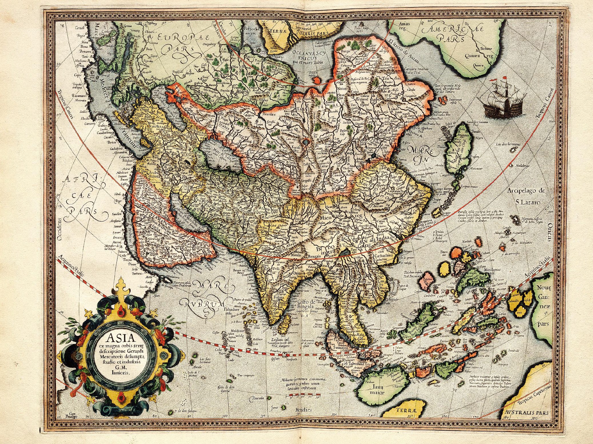
The Art of Maps: Map of America from Atlas sive Cosmographicae by Gerardus Mercator (1595)

America From Mercator 41 page
Atlas sive Cosmographicae by Gerardus Mercator (1595)

The Fleming Gerard Mercator (1512-1594) is rightfully regarded as the most important scientific cartographer of the Renaissance. With two contemporaries, the geographer Abraham Ortelius and the printer and publisher Christoffel Plantijn,he is considered the father of commercial cartography in the Netherlands.Even during his lifetime his maps, globes and atlases found their way all over the world.Mercator established his reputation mainly through his new projection method. The meridians and parallels are positioned at right angles to each other.If the distances between the meridians are equal, they progressively become larger between the parallels from the equator to the poles.This is why the latitude becomes wider the closer you get to one of the poles and why the part of the Earth in the upper latitudes exhibits excessive proportions.The advantage of this method was the far greater degree of certainty and accuracy in determining shipping routes.In 1585, Mercator published the first three parts of his own book of maps in one volume,which he called Atlas.The second edition appeared in 1589, with the addition of a fourth part. The first complete edition was compiled by his heirs in 1595 one year after his death.Walter Ghim,mayor of Duisburg the city where Mercator had lived for a long time,wrote the accompanying Mercator biography.It was the first time that a book of maps was referred to as an Atlas.Commercially speaking,however,the Atlas was not a success thanks to formidable competition from the Theatrum orbis terrarum by Abraham Ortelius,published in 1570,which by the end of the century had been reprinted more than twenty times.


The Art Of Maps:

Wednesday, 9 March 2011

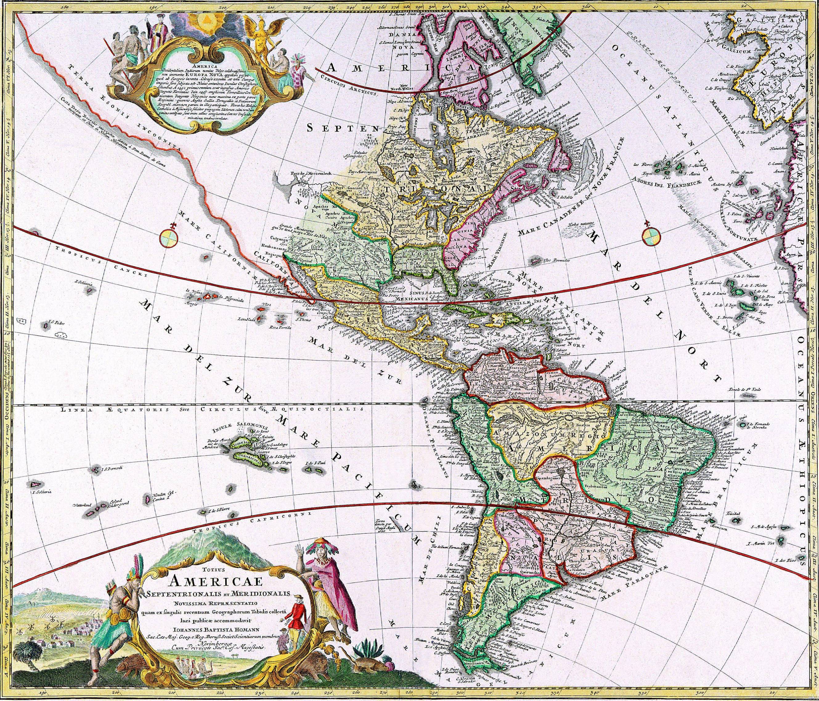
The Art of Maps:Johann Baptiste Homann [California as an Island]

Johann Baptiste Homann - Totius Americae Septentrionalis
Johann Baptiste Homann - Title: Totius Americae Septentrionalis et Meridionalis Novissima Representatio . . . [California as an Island]

Map Maker: Johann Baptiste Homann
Place / Date: Nuremberg / 1710
Coloring: Hand Colored
Size: 22.5 x 19 inches
Condition: VG
Price: $1,800.00

Description:

Striking dark impression of the first edition JB Homann's map of America, showing California as an Island on the second Sanson model and pre-datingHomann's privilege.

The Straits of Anian are shown forming a Northwest Passage between California and the mythical Terra Esonis, which forms a nearly continuous land bridge from the Northwest to Asia. The Pays de Moozemleck is shown east of the Straits of Anian. This landmark remains virtually unchanged through all of Homann's maps of America, despite the transition to a peninsular California, resulting in an odd change from a coastal to an apparently landlocked position for this landmark.

The Great Lakes are shown with some detail. The Mississippi River shows the results of the early French Jesuit explorations, with its sources extending far North of the limits of the maps produced 20 and 30 years earlier, although Le Moyne's mythical lake in the Southeastern US remains. The title cartouche is based upon De Fer's landmark map of 1699. The top cartouche is based upon De L'Isle's 1703 map of Canada.

Fine dark impression, reflecting a very early pull fom the copperplate.

Condition Description: Old Color. Minor fold split at bottom centerfold and minor tear to the left of the fold, repaired on verso.


The Art Of Maps:

Monday, 28 February 2011

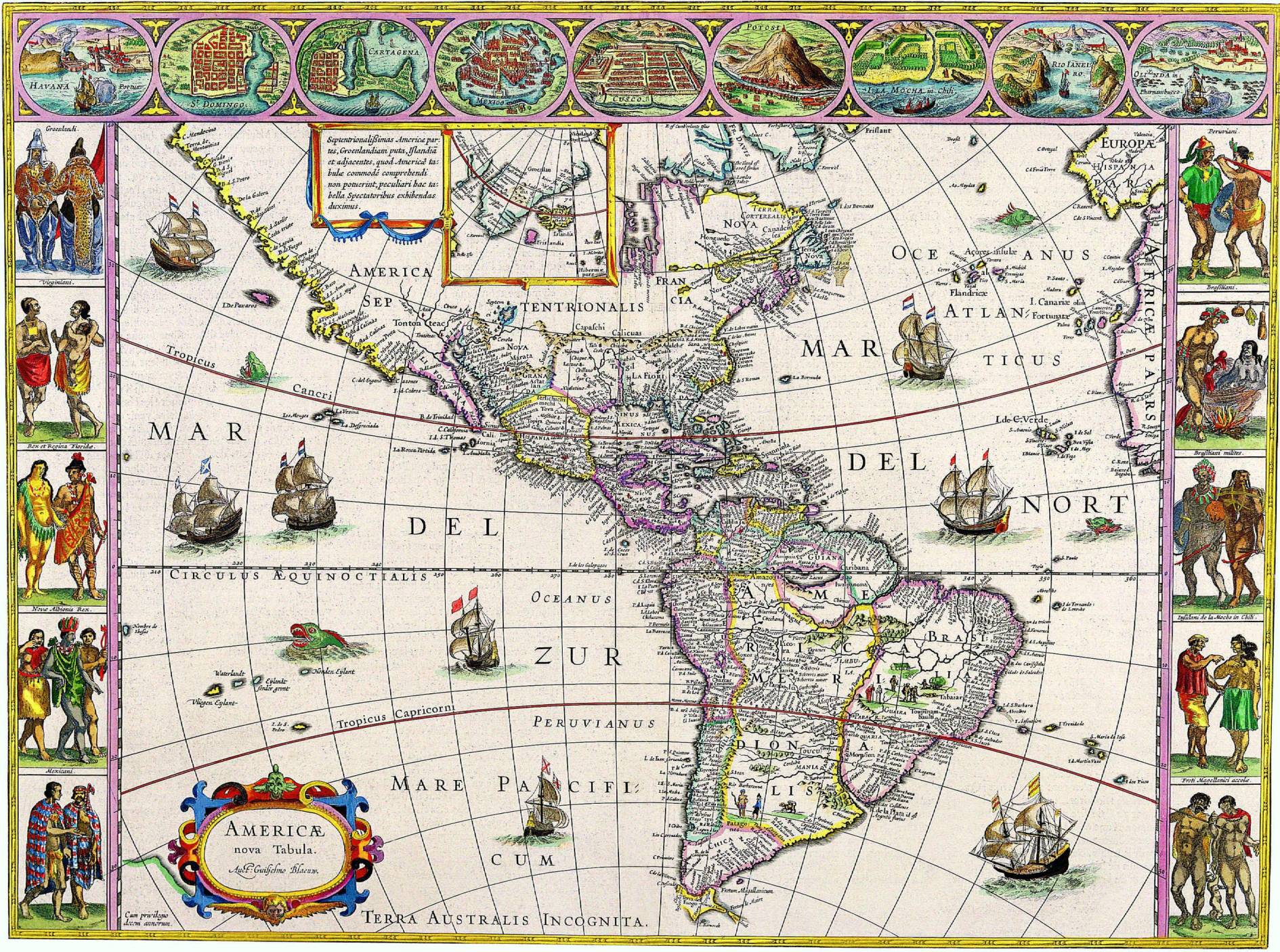
The Art of Maps: Americae Nova Tabula

BLAEU, W.
Americae Nova Tabula.
Amsterdam, 1645
Size: 16.0 x 22.0 inches.
40.6 x 55.9 cm.
The delineation of the coast and the nomenclature on both the Pacific and Atlantic coasts are basically Spanish in origin and follow the maps of Ortelius and Wytfliet. To these Willem Blaeu has inserted on the East Coast the English names given by the Roanoke colonists in Virginia and by Frobisher, Davis and Hudson to the far north.
He has added French names in Florida and along the St Lawrence. European geographers still had no knowledge of the extent of the Mississippi. From the expedition journals of De Soto (1539-43) they had inferred an extensive range of east west trending mountains north of the Gulf of Mexico, precluding any great river system.
The Great Lakes were as yet unknown, although Champlain had reached Huron and had heard of the lakes from Coral Indians and had, in 1632, published his own map showing the region.

The Art Of Maps:


The Art of Maps: Map of America from Atlas sive Cosmographicae by Gerardus Mercator (1595)
The Art of Maps: Europa Delineata juxta Obfervationes Excellorum – Vindel 1760
The Art of Maps: PIRI REIS MAP
The Art of Maps: Map of Europe from Atlas sive Cosmographicae by Gerardus Mercator (1595)
The Art of maps: John Speed: Asia with the Islands adioyning described, the atire of the people, & Townes of importance, all of them newly augmented . . . 1626
The Art of Maps:Johann Baptiste Homann [California as an Island]
The Art of maps:Matthias Quad – Map of North America 1593
The Art of Maps: Americae Nova Tabula
Sightseeing Map Locations Bulgaria
The Art of Maps: CORNELIS DANCKERTS Nieuw Aerdsch Pley MAP

The Art of Maps: Map of Asia from Atlas sive Cosmographicae by Gerardus Mercator (1595)


Atlas sive Cosmographicae by Gerardus Mercator (1595)

The Fleming Gerard Mercator (1512-1594) is rightfully regarded as the most important scientific cartographer of the Renaissance. With two contemporaries, the geographer Abraham Ortelius and the printer and publisher Christoffel Plantijn,he is considered the father of commercial cartography in the Netherlands.Even during his lifetime his maps, globes and atlases found their way all over the world.Mercator established his reputation mainly through his new projection method. The meridians and parallels are positioned at right angles to each other.If the distances between the meridians are equal, they progressively become larger between the parallels from the equator to the poles.This is why the latitude becomes wider the closer you get to one of the poles and why the part of the Earth in the upper latitudes exhibits excessive proportions.The advantage of this method was the far greater degree of certainty and accuracy in determining shipping routes.In 1585, Mercator published the first three parts of his own book of maps in one volume,which he called Atlas.The second edition appeared in 1589, with the addition of a fourth part. The first complete edition was compiled by his heirs in 1595 one year after his death.Walter Ghim,mayor of Duisburg the city where Mercator had lived for a long time,wrote the accompanying Mercator biography.It was the first time that a book of maps was referred to as an Atlas.Commercially speaking,however,the Atlas was not a success thanks to formidable competition from the Theatrum orbis terrarum by Abraham Ortelius,published in 1570,which by the end of the century had been reprinted more than twenty times.

The Art Of Maps:

The Art of Maps: Map of America from Atlas sive Cosmographicae by Gerardus Mercator (1595)
The Art of Maps: Europa Delineata juxta Obfervationes Excellorum – Vindel 1760
The Art of Maps: PIRI REIS MAP
The Art of Maps: Map of Europe from Atlas sive Cosmographicae by Gerardus Mercator (1595)
The Art of maps: John Speed: Asia with the Islands adioyning described, the atire of the people, & Townes of importance, all of them newly augmented . . . 1626
The Art of Maps:Johann Baptiste Homann [California as an Island]
The Art of maps:Matthias Quad – Map of North America 1593
The Art of Maps: Americae Nova Tabula
Sightseeing Map Locations Bulgaria
The Art of Maps: CORNELIS DANCKERTS Nieuw Aerdsch Pley MAP

Share this: