Saturday, 13 August 2011

The Art of Maps: Cornelis Danckerts Nova Persiae Armeniae Natoliae et Arabiae


Nova Persiae Armeniae Natoliae et Arabiae


Cornelis Danckerts
Place / Date: Amsterdam / 1680
Coloring: Hand Colored
Size: 22 x 19 inches
Condition: VG
Description:

Rare Cornelis Danckerts edition of this decorative and highly desireable map of the region bounded by the Saudi Peninsula, Red Sea, Nile River, Cyprus, Asia Minor, the Gulf of Aden, Indian Ocean, Armenia, the Caspian Sea, Afganistan and the Indian Ocean, centered on the Persian Gulf.

Includes two attractive cartouches, ships at sea and marvelous geographical detail within the map. One of the few available Dutch maps to mention Armenia in the title of the map and one of the most detailed of the region.

While the map appears similar to De Wit's map of the same title, it is a completely different copper plate, with many noticable differences.


Condition Description: Several minor tears in the left margin, repaired on verso The maps do not touch the printed image.

Thursday, 21 July 2011

The Art of Maps: Nova et Accuratissima Totius Terrarum Orbis Tabula Auctore Joanne Blaeu


Nova et Accuratissima Totius Terrarum Orbis Tabula Auctore Joanne Blaeu


Map Maker: Willem Janszoon Blaeu

Place / Date: Amsterdam / 1662

Coloring: Hand Colored

Size: 21.5 x 16 inches

Price: $22,500.00


Nice old color example of Blaeu's double hemisphere map of the World, originally prepared by Joan Blaeu for his Atlas Maior in 1662. The map was also included in contemporary composite sea atlases of the period by Goos and others.

Unlike Blaeu's first world map which appeared in the majority of his atlases and was done on the Mercator projection, Blaeu utilizes a double hemisphere format and depicts California as an island.

This double hemisphere map was prepared at the end of the firm's publishing history and is much rarer than its predecessor. The engraving, layout and elegance of decoration are all of the highest standard. The map depicts celestial figures seated among the clouds and representations of the four season below, with each figure seated in a chariot drawn by beasts and birds. Because of the relatively scarity of this map and Blaeu's prominence as one of the most influential and decorative map makers of the Golden Age of Dutch Cartography, this map has become especially sought after by collectors and increasingly scarce on the market.


Condition Description: Old color. Split and tear in upper margin, entering image, but well repaired on verso. Minor tear in lower left margin, just entering printed image. Some minor soiling in the image and in the blank margins.

Monday, 11 July 2011

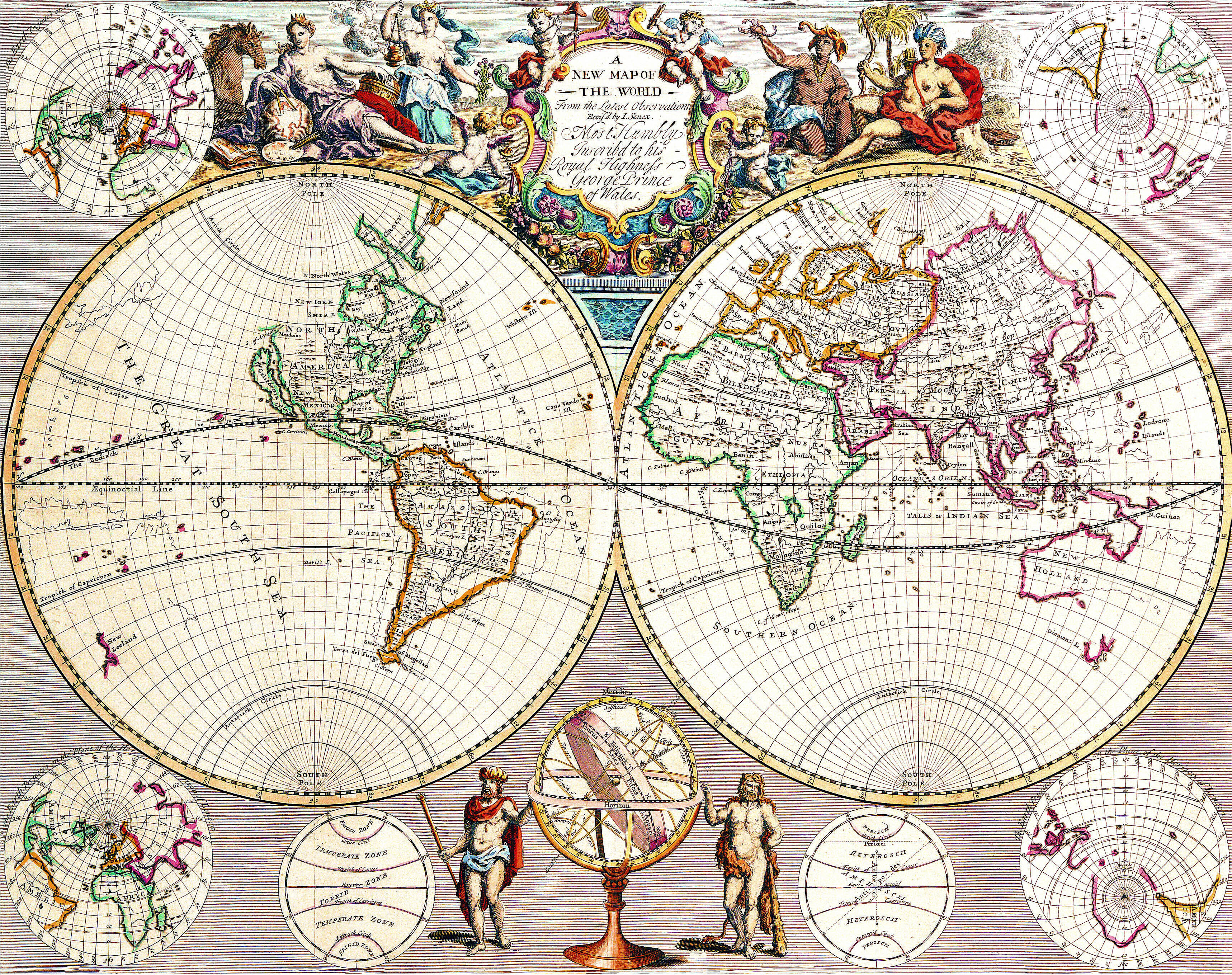
The Art of Maps: New Map of The World From The Latest Observations

A New Map of The World From The Latest Observations…Most Humbly Inscribed to his Royal Highness George Prince of Wales


A New Map of The World From The Latest Observations…Most Humbly Inscribed to his Royal Highness George Prince of Wales

Map Maker: John Senex

Price: $3,600.00

Size: 21.5 x 16.5 inches

Place / Date: London / 1721

Condition: VG

Coloring: Hand Colored

Description:

Striking double hemisphere map of the World, from John Senex's New General Atlas, first published in 1721.

Senex's map provides a fine look at a number of the surviving myths and cartographic inaccuracies of the early 18th Century. California is shown as an Island, both New Zealand and Australia have incomplete coastlines, there is no sign of Antarctica, New Guinea is still shown as connected to Australia, and the Northwest Coast of America ends near the present day Straits of Juan de Fuca, with a speculative remnant of the old land bridge between Asia and America shown, but without meaningful detail.

The map includes 4 smaller Northern and Southern Hemisphere projections, an armillary and other scientific drawings.  A fine allegorical vignette across the top shows the four continents as womena, with Europe, the scholar, studying the globe, Asia, the exotic trading partner, with an urn of incense, while the primitive Africa and America appear on the far side of the title cartouche.


Thursday, 30 June 2011

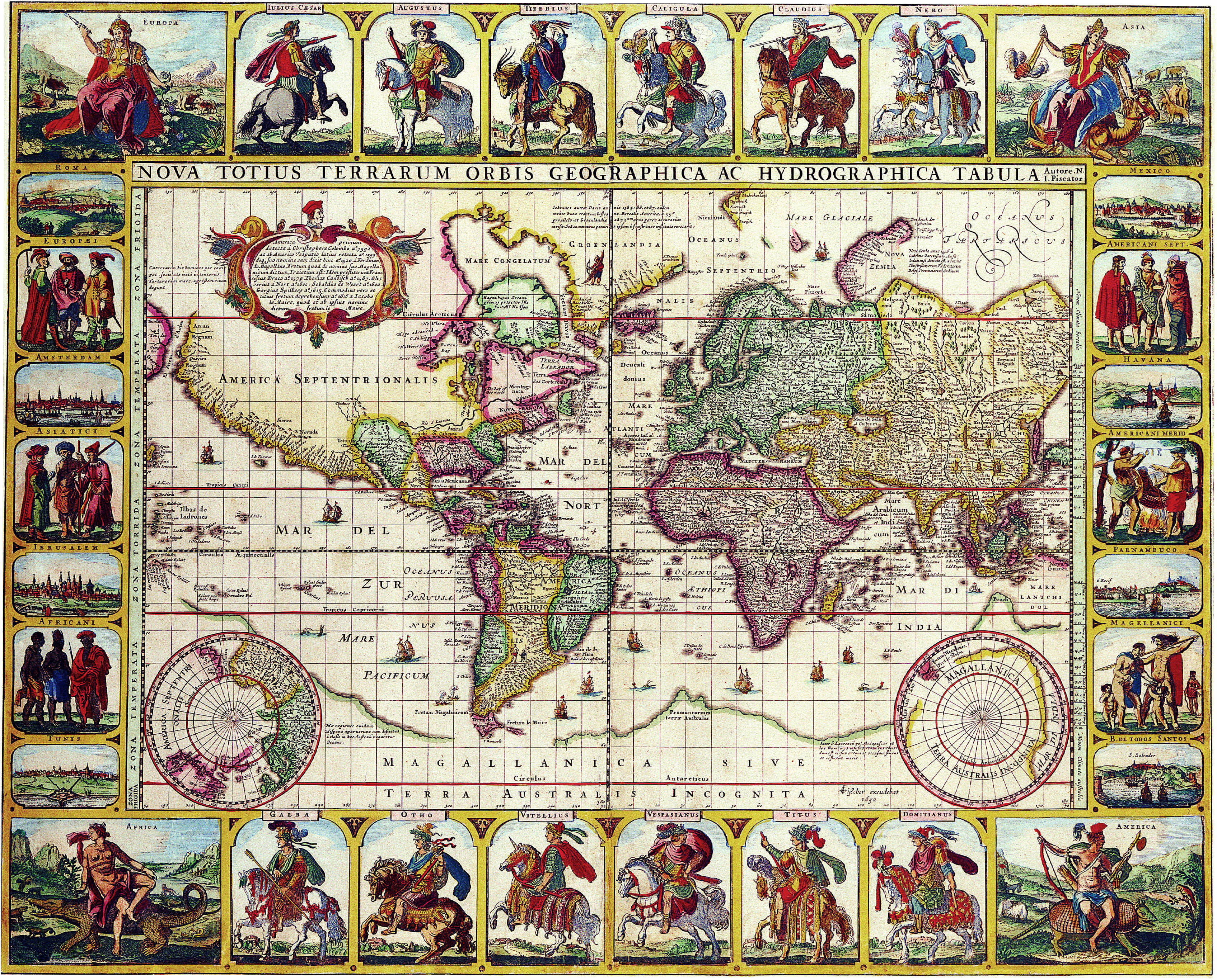
Nova Totius Terrarum Orbis Geographica Ac Hydrographica Tabula Autore N I Piscator . . . 1652


Nova Totius Terrarum Orbis Geographica Ac Hydrographica Tabula Autore N I Piscator . . . 1652

Map Maker: Claes Janszoon Visscher

Place / Date: Amsterdam / 1652

Coloring: Hand Colored

Size: 22.5 x 18 inches

Condition: VG


Description:

Nice example of Claes Janszoon Visscher 's rare Twelve Caesars world map.

CJ Visscher's world maps are among the most spectacular world maps published in the 17th Century.
The present map is one of four world maps with decorative panels issued by Visscher between 1614 and 1652.
In 1639, Visscher prepared this equisite world map on Mercator's projection in the style of Blaeu and Jansson.
This example is the final state of that map from 1652, determned by the date engraved in the lower right image,
next to the small southern hemispheric map.

Embellished with scenes of 12 Roman emperors mounted on horses in full battle gear - thus often called
the "Twelve Caesars Map" - along with representations of the four continents, six costumed figures showing
the mode of dress in each of regions (Europeans, Asiatici, Africani, North Ameicans, South Americans and Magellanici),
and including eight city views (Rome, Amsterdam, Jerusalem, Tunis, Mexico City, Havana, Parnambuco and Bahio Todos Santos).

The cartography is very up to date for the period, showing the discovery of Hudson's Bay and the course
of the St. Lawrence river.  The Straits of le Maire and Magellan are shown, with the massive Magellanica Sive Terra
Australis Incognita (unnown Southern lands still prominently appearing).  Beach is still shown in the region that would
become Australia, based upon the reports of Marco Polo. The early Dutch discoveries in what would become northern Australia are shown.
Marvelous (although completely fictional) California Coastline appears, heading north toward the Straits of Annian, only a few short miles from NE Asia.

The detail in the map is quite remarkable.  The engraver of the map is not known, but Shirley surmises that it was probably Pieter Goos.
A visually stunning example.


Condition Description:
Old Color. A bit age toned and soiled near lower part of centerfold. A few small tears in lower margin repaired on verso.
In general, a very nice example of this rare map, which is frequently trimmed into the map image.

Saturday, 21 May 2011

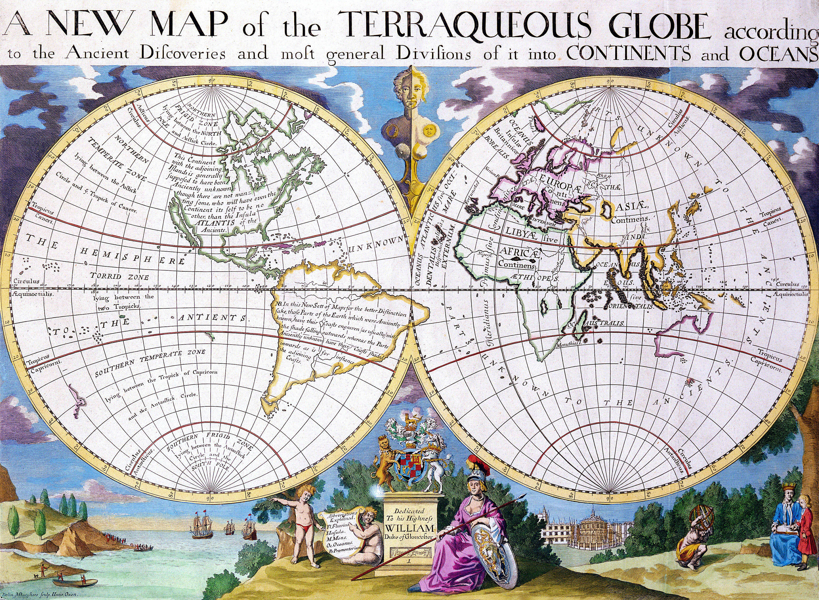
The Art of Maps: A New Map Of The Terraqueous Globe According To The Ancient Discoveries And Most General Divisions Of It Into Continents And Oceans


A New Map Of The Terraqueous Globe According To The Ancient Discoveries And Most General Divisions Of It Into Continents And Oceans
Edward Wells (after)
Michael Burghers (c. 1653-1727) (engraver)
Oxford: c. 1700-1738
Engraving on laid paper with Strasburg Bend & Lily watermark [Churchill 434]
17.25 x 21.25 inches overall
14.5 x 20.5 inches image


Instructional map which depicts the world in classical times, a companion piece to a map of the modern world, both of which were published by Edward Wells, teacher of mathematics and geography at Christchurch College of Oxford University. Wells labels North America as Atlantis and offers this speculation that the New World is in fact the legendary "lost continent": "This Continent with the adjoining islands is generally supposed to have been Anciently unknown though there are not wanting some, who will have even the Continent itself to be no other than the Insula Atlantis of the Ancients." California is shown as an island. Below the hemispheres is a vignette dedicated to His Highness William, Duke of Gloucester, who appears with his tutor under the tree on the right. The 13-year-old William, heir to the throne, began studies at Christchurch in 1700 at the age of 11, and died a few months after the map was issued. On either side of this are small landscapes, one of ships arriving in the New World and one of the Radcliffe Camera in Oxford.

Michael Burghers was an engraver and draftsman from Holland, who came to England and settled in Oxford in 1673. There he worked under David Loggan and succeeded him as Engraver to the University. Burghers engraved the first Oxford Almanack in 1676, and continued to engrave most of them for the next 43 years. He also illustrated books and produced architectural, botanical and portrait engravings.


Sunday, 17 April 2011

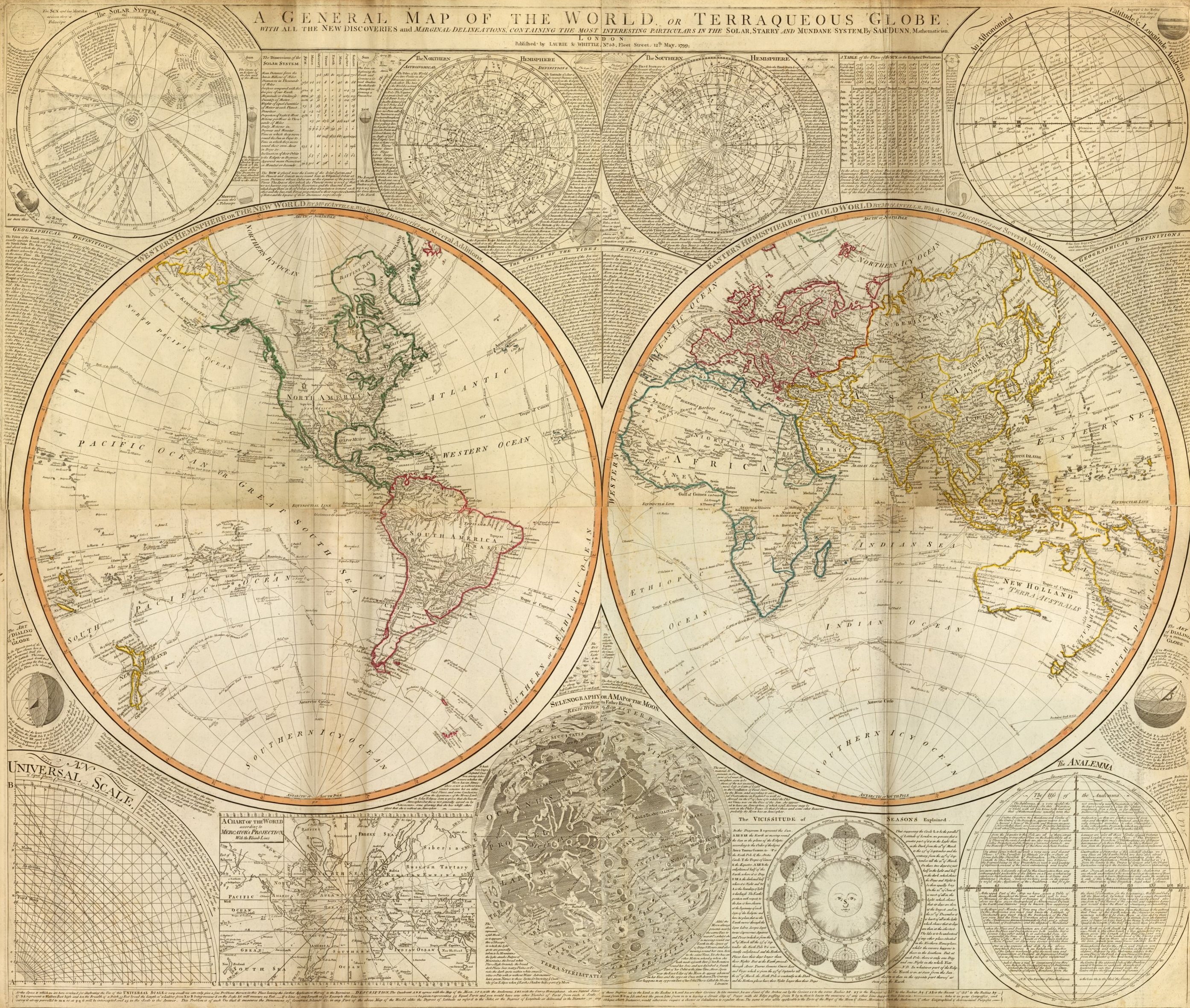
The Art of Maps: Jean Baptiste Bourguignon- A general map of the World or terraqueous globe with...


Author: Anville, Jean Baptiste Bourguignon d, 1697-1782; Dunn, Samuel; Riccioli, Giovanni Battista; Robert Laurie &
James Whittle
Date: 1799
Short Title: Composite: World.
Publisher: Laurie & Whittle London
Type: Composite Map
Obj Height cm: 105
Obj Width cm: 124
Scale 1: 43,000,000
Note:
Digital composite of north and south halves of hand colored engraved map. Relief shown pictorially. Contents: Western Hemisphere or the New World by Mr. d'Anville, with new discoveries and several additions -- Eastern Hemisphere or the Old World by Mr. d'Anville, with the new discoveries and several additions. Ancillary maps or charts: The Solar System -- The Northern Hemisphere -- The Southern Hemisphere -- An astronomical latitude & longitude analemma -- An universal scale -- A chart of the World according to Mercator's projection, with the rhumb lines -- Selenography or A map of the Moon according to Father Riccioli -- The vicissitude of seasons explained -- The analemma. Printed on 4 sheets; joined as 2.
World Area: World
Subject: Celestial
Full Title:
(Composite of) A general map of the World or terraqueous globe with all the new discoveries and marginal delineations, containing the most interesting particulars of the solar, starry and mundane system, by Saml. Dunn, mathematician. London, Published by Laurie & Whittle, No. 53, Fleet Street, 12th May, 1799.
Author: Anville, Jean Baptiste Bourguignon d, 1697-1782; Dunn, Samuel; Riccioli, Giovanni Battista; Robert Laurie &James WhittleDate: 1799Short Title: Composite: World.Publisher: Laurie & Whittle LondonType: Composite MapObj Height cm: 105Obj Width cm: 124Scale 1: 43,000,000
Note:Digital composite of north and south halves of hand colored engraved map. Relief shown pictorially. Contents: Western Hemisphere or the New World by Mr. d'Anville, with new discoveries and several additions -- Eastern Hemisphere or the Old World by Mr. d'Anville, with the new discoveries and several additions. Ancillary maps or charts: The Solar System -- The Northern Hemisphere -- The Southern Hemisphere -- An astronomical latitude & longitude analemma -- An universal scale -- A chart of the World according to Mercator's projection, with the rhumb lines -- Selenography or A map of the Moon according to Father Riccioli -- The vicissitude of seasons explained -- The analemma. Printed on 4 sheets; joined as 2.


The Art Of Maps:

Saturday, 26 March 2011

The Art of maps: John Speed: Asia with the Islands adioyning described, the atire of the people, & Townes of importance, all of them newly augmented . . . 1626

Old Maps John Speed Asia with the Islands adioyning described 1626
Asia with the Islands adioyning described, the atire of the people, & Townes of importance, all of them newly augmented . . . 1626
Map Maker: John Speed Place

Date: London / 1676

Coloring: Hand Colored             Size: 20 x 15 inches                Condition: VG

Description:

Striking example of Speed's map of Asia, decorated with 10 costumed figures and 8 town plans of important early Asian cities (Candy, Goa, Damascus, Jerusalem, Orumus, Bantam, Aden and Macao). Korea is shown as a slender oddly projected Peninsula.

The Great Wall of China is shown, along with and Elephant above the source of the Ganges. A nice simple/naïve Northeast passage is shown, along with a piece of North America and sea monsters in the extreme North Pacific and Southern Indian Sea. The text on the verso presents a fascinating Anglocentric view of Asia in the early 17th Century.


The Art Of Maps:

Share this: