Thursday 27 October 2011

The Art of Maps: Hubert Jaillot Estats de L'Empire des Turqs en Europe, ou sont les Beglerbeglicz our Gouvernements 1692


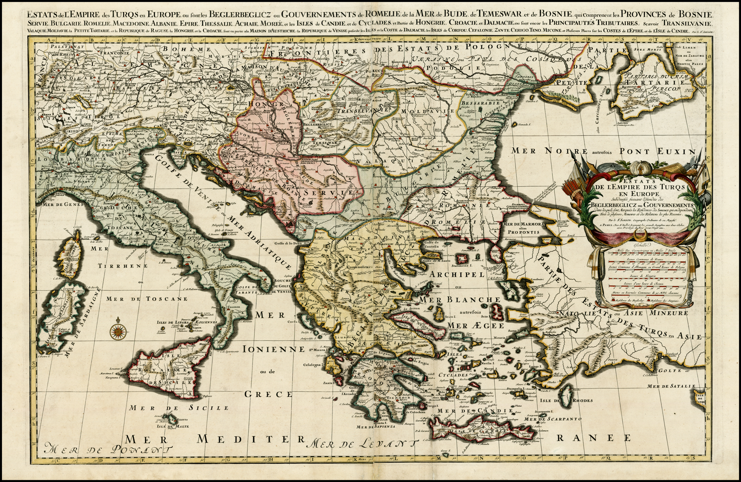
Hubert Jaillot:  Estats de L'Empire des Turqs en Europe, ou sont les Beglerbeglicz our Gouvernements


Estats de L'Empire des Turqs en Europe, ou sont les Beglerbeglicz our Gouvernements . . .
Hubert Jaillot
Amsterdam / 1692
Hand Colored


Size: 34 x 22 inches


Scarce large format map of the Turkish Empire in Europe and the Eastern Mediterranean, published by Jaillot, based upon the earlier maps of Nicolas Sanson.

Thursday 20 October 2011

The Art of Maps: Henri Chatelain Carte Ancienne et Moderne des Differents Etats et Pais situez au Long du Danube pour servir a L'Intelligence De L'Histoire


Henri Chatelain:  Carte Ancienne et Moderne des Differents Etats et Pais situez au Long du Danube, pour servir a L'Intelligence De L'Histoire


Carte Ancienne et Moderne des Differents Etats et Pais situez au Long du Danube, pour servir a L'Intelligence De L'Histoire


Henri Chatelain


Amsterdam / 1719


Uncolored


Size: 18 x 14 inches


Detailed map of the region north of the Adriatic Sea and centered on the Danube River, from Croatia to the Black Sea.


Surrounded by descriptive French text.

Wednesday 12 October 2011

The Art of Maps: John Pinkerton Turkey In Europe


John Pinkerton:  Turkey In Europe


Turkey In Europe
John Pinkerton
London / 1812
Hand Colored


Size: 28 x 20 inches


An excellent detailed regional map of Bulgaria, Turkey and Greece, showing towns, roads, rivers, mountains, lakes, and other items of interest. Handcolored by regions.


Condition Description: One minor spot

Friday 7 October 2011

The Art of Maps: Jan Jansson America Septentrionalis 1641


 Jan Jansson: America Septentrionalis


Jan Jansson
1641
Hand Colored
Size: 22 x 18.5 inches


Nice old color example of Jansson's map of North America, called by Burden the single most influential map in perpetuating the myth of California as an Island.


The map is a well-researched amalgam of the best cartographic resources available. In the West. Jannson draws heavily upon Briggs 1625 map of North America. An unnamed lake still feeds the Rio de Norto (Rio Grande), which is incorrectly shown flowing southwest into the Sea of Cortez. The Gulf of Mexico and Florida are based upon Hessel Gerritsz’s map of 1631. The east coast draws from a number of sources. Jamestown is shown. Novum Belgium is unlike prior maps between the Delaware and Hudson, being greatly elongated. New Amsterdam is not shown, but Ft. Orange is located. The place names in New England are based upon John Smith's map of 1616. The Gulf of St. Lawrence appears to follow De Laet. The map is richly illustrated with ships, sea monsters and animals in the interior parts of North America.


An essential map for collectors of North America and California, being the first atlas map to show North America only, the first widely disseminated map of California as an island and a host of other important features. Second state per Burden, with Latin text on verso.


Very faint discoloration at centerfold, else a very nice example, in full orginal color.

Tuesday 4 October 2011

The Art Of Maps Nicholas Sanson Amerique Septentrionale par Sanson d Abbeville Geog du Roy 1650


Amerique Septentrionale par N. Sanson d'Abbeville Geog. du Roy 1650


Map Maker: Nicholas Sanson
1650
Hand Colored
Size: 21.5 x 15.25 inches


Fine example of the first obtainable state of Sanson's landmark map of North America.


Sanson's map the first map to depict the Great Lakes in a recognizable form, and the first to name Lake Ontario and Lake Superior. In  Sanson drew on information derived from The Jesuit Relations, published in Paris in 1649, which provided contemporary accounts of many regions of North America visited by French missionaries.  His sources included Father Paul Ragueneau's account of his visit to Niagara Falls and Jean Nicollet's discovery of Lake Michigan in 1634.  Montreal is named, having been founded by the Sieur de Maisonneuve in 1642.


In the Southwest, Sanson draws up the reports of the travels in New Mexico of Father Alonso Benavides Memorial, published in Madrid in 1630. It is the first printed map to label "S[anta] Fe" (incorrectly shown  the Rio Grande) and the "Apache," Navajo" and the "Taosij" (Taos) Indian regions. California is shown as a large island, based largely on Johannes de Laet's map of 1630. The region in the north called "Conibas" represents a mythical land between North America and Asia.  The area delineated as "Mer Glaciale" is a reference to the Northwest Passage. On the east coast "N[ouvelle] Amsterdam"  appears (New York), as does the first appearance on a printed map of  "N[ouvelle] Suede," the Swedish colony centered on Fort Christina, founded on the site of present-day Wilmington, Delaware in 1638.


This is the second state of the map.  The first, known in only 2 examples (Burden), includes a number of place names north of California (Anian, Quivira, Nouvelle Albion, Conibas) which do not appear on later editions.  The second state can be distinguished from the third state by the treatment of Lake Ontario. In the second state, Lake Ontario is not shaded in like the other Great Lakes and looks like a series of Rivers.  In the third state, it is shaded like Lake Ontario.


Sanson is regarded as the founder of the 'French School' of cartography. His map of North America was the most advanced depiction of the continent in the mid-17th Century and was the source map for most subsequent maps for the next 40 years.Sanson was the first to employ a sinusoidal projection, which was also adopted by John Flamsteed, the first Royal Astronomer appointed by the King of England.  


Saturday 1 October 2011

The Art of Maps: Map of Rvssia from Atlas sive Cosmographicae by Gerardus Mercator (1595)


Atlas sive Cosmographicae by Gerardus Mercator (1595)

The Fleming Gerard Mercator (1512-1594) is rightfully regarded as the most important scientific cartographer of the Renaissance. With two contemporaries, the geographer Abraham Ortelius and the printer and publisher Christoffel Plantijn,he is considered the father of commercial cartography in the Netherlands.Even during his lifetime his maps, globes and atlases found their way all over the world.Mercator established his reputation mainly through his new projection method. The meridians and parallels are positioned at right angles to each other.If the distances between the meridians are equal, they progressively become larger between the parallels from the equator to the poles.This is why the latitude becomes wider the closer you get to one of the poles and why the part of the Earth in the upper latitudes exhibits excessive proportions.The advantage of this method was the far greater degree of certainty and accuracy in determining shipping routes.In 1585, Mercator published the first three parts of his own book of maps in one volume,which he called Atlas.The second edition appeared in 1589, with the addition of a fourth part. The first complete edition was compiled by his heirs in 1595 one year after his death.Walter Ghim,mayor of Duisburg the city where Mercator had lived for a long time,wrote the accompanying Mercator biography.It was the first time that a book of maps was referred to as an Atlas.Commercially speaking,however,the Atlas was not a success thanks to formidable competition from the Theatrum orbis terrarum by Abraham Ortelius,published in 1570,which by the end of the century had been reprinted more than twenty times.


The Art Of Maps:

Share this: